
DRONESKY HR
An iOS and web flight planning app for drone pilots in Croatia
What is DroneSky HR
DroneSky HR is a specialized iOS and web app developed by Saluto‑Team for drone pilots flying in Croatia.
It brings together all the key information you need for safe and compliant flights – from airspace zones and rules to detailed, altitude‑aware weather forecasts for your chosen location.
Designed for both recreational and professional operators who want to plan every flight responsibly, DroneSky HR is available as a native iOS app and as a web app that works on any device and platform – no installation required, directly in your browser.
Key features of DroneSky HR
• Interactive map with a clear display of no‑fly and restricted zones (CTR, TMA, special use areas and UAS geographical zones).
• National parks and nature parks shown with their real‑world boundaries, so you immediately see where flying is further restricted or prohibited – to our knowledge, no other app offers this level of detail for Croatia.
• Informative overview of altitude limits and basic flight rules for the selected area.
• Flight planning with detailed weather forecasts up to 48 hours ahead, plus a conditions outlook up to 10 days in advance.
• Pre‑ and post‑flight checklist with PDF export including all checked items, flight altitude, flight duration, location and time of check.
• Import and export of flying locations – easily transfer your spots between devices or share them with others.
• Save your favourite flying locations directly from the map or by using search.
• Detailed weather parameters important for safe drone operations (e.g. wind, precipitation, visibility), tailored to your planned flight altitude.
• Simple, clear interface suitable for both recreational and professional operators – available on iOS and all modern web browsers.
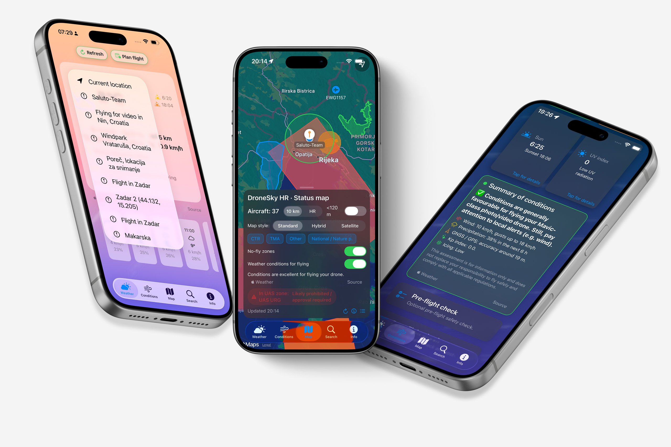
All key weather conditions – detailed, in one place
In addition to airspace information, DroneSky HR gives you a detailed view of weather conditions at your flight location across different altitude layers – wind speed and gusts, risk of precipitation, icing and sudden wind changes. All of these values are crucial for assessing the risk of flying a drone at any location.
DroneSky HR also tracks the sun’s position on the horizon, clearly showing how much time is left until sunset. By moving the sun path slider, you can quickly check when the light will be best for your scenario – from golden hour shots to a completely different mood. UV index forecasts further help protect both you and your drone, especially in summer when UV radiation is higher and hot conditions put extra stress on the aircraft.
Risk assessment for your drone and flight planning
One of DroneSky HR’s key features is the drone profile you use for flying. Instead of a generic safety estimate, DroneSky HR assesses risk based on your selected drone category, and both the visual and textual conclusions are tailored to that profile – you clearly see whether a flight is considered safe or if there is an elevated risk you should pay attention to.
Flight planning lets you prepare each mission in advance. By selecting a location from the map or via search and defining flight duration, altitude, date and time, you get a detailed risk assessment for the chosen time slot. You can save, rename and delete planned flights as needed, giving you a dedicated flight planner in one place – clear, organized and always at hand.

A look inside DroneSky HR
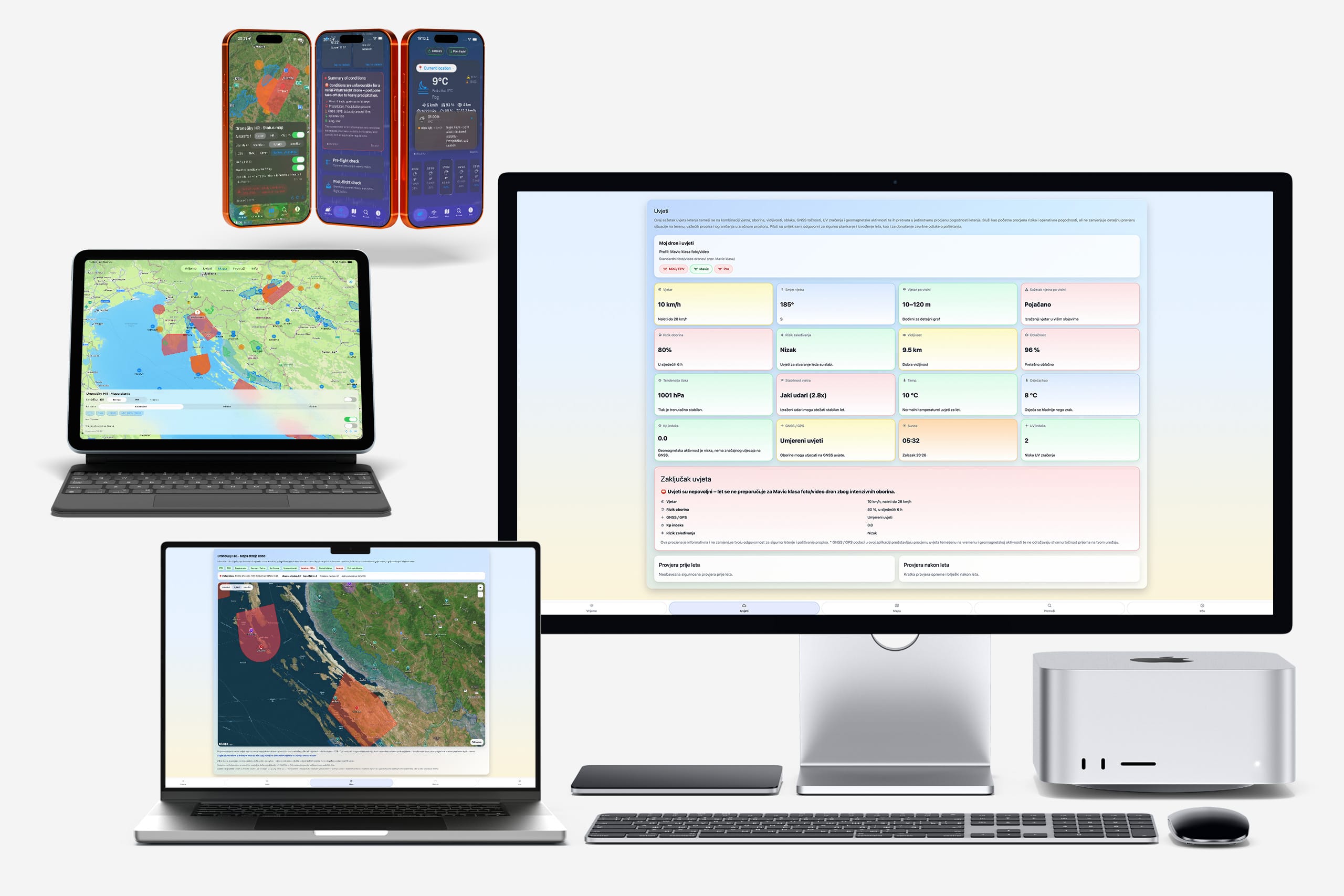
Below you can see a selection of interface screens from DroneSky HR. Together, they bring all the key data you need for safe and responsible drone flights into one place – available on iOS and in your web browser.
• Current weather data, updated almost in real time for your chosen location or a searched location.
• Altitude‑based weather – detailed conditions broken down by height layers for the selected location.
• Airspace map with clearly marked no‑fly and restricted zones, including national parks and nature parks with their real‑world boundaries (as far as we know, unique among drone apps in Croatia).
• Quick flight risk overview – key information about zone, wind and conditions before take‑off.
• Visual weather risk overlay directly on the map.
• Live overview of current air traffic over Croatia.
• Three main drone profiles to choose from, with risk assessment adapted to the selected profile.
• Save, edit and share locations directly within DroneSky HR.
• Short‑term risk outlook for precipitation, wind, gusts, wind at altitude and icing in the next few hours.
• Daily sun path, sunrise, sunset and remaining daylight at the horizon.
• Links to relevant institutions and regulations for legal drone flying and aerial imaging in Croatia (CCAA, HKZP/AMC portal, DGU and other official information sources).

All relevant flight information in one place
Current weather data, airspace zones map, flight risk, drone profiles, forecasts of key parameters

GEO zones and aircraft details
Which flight zone you are in, where the nearest aircraft is, and whether it is wise to take off.

Real-time weather conditions
All key detailed weather data you need for a safe flight assessment at your chosen location.

Current sky status above you
Display of aircraft, their distance from a specific location, altitude, and flight zones within Croatia.

Automatic detection and display of zones
Whether you are in a no-fly zone, need special authorization, and if the flight is legal.

Personalized drone profile for risk assessment
Selection of drone category, calculation of parameters, and flight risk based on the chosen category.

Flight planning directly in the app
Selecting a map location, drone profile, date and time, flight altitude, and duration.

Saving and editing planned flights
Reliable risk assessment for flights up to 48 hours in advance, with the ability to change flight time, parameters, or location.

Weather data and visual interpretation
Meteorological data with risk assessment and visual risk indicators, plus an animated background based on current conditions.

Wind forecast, gusts, and vertical profile
Wind speed, direction, gusts, and wind profiles by altitude up to 120 meters.

Sun position on the horizon, path check, UV index
Where the sun is on the horizon, how long until sunset, “golden hour”, and civil dawn and dusk.

Precipitation and icing risk
Six-hour forecast with risk assessment for precipitation and potential ice formation on the drone.

Custom locations for quick selection
Saving locations directly from the map, searching locations, and setting a personal “hot spot” for each flight.

Search and edit locations
Fast search, editing, adding, and deleting of selected locations.

All information for legal flying in one place
Links to all relevant authorities and regulations for flying and aerial filming.

National parks and nature parks
Unique feature that displays national parks and nature parks with their real boundaries on the map.
All relevant flight information in one place
Current weather data, airspace zones map, flight risk, drone profiles, forecasts of key parameters
GEO zones and aircraft details
Which flight zone you are in, where the nearest aircraft is, and whether it is wise to take off.
Real-time weather conditions
All key detailed weather data you need for a safe flight assessment at your chosen location.
Current sky status above you
Display of aircraft, their distance from a specific location, altitude, and flight zones within Croatia.
Automatic detection and display of zones
Whether you are in a no-fly zone, need special authorization, and if the flight is legal.
Personalized drone profile for risk assessment
Selection of drone category, calculation of parameters, and flight risk based on the chosen category.
Flight planning directly in the app
Selecting a map location, drone profile, date and time, flight altitude, and duration.
Saving and editing planned flights
Reliable risk assessment for flights up to 48 hours in advance, with the ability to change flight time, parameters, or location.
Weather data and visual interpretation
Meteorological data with risk assessment and visual risk indicators, plus an animated background based on current conditions.
Wind forecast, gusts, and vertical profile
Wind speed, direction, gusts, and wind profiles by altitude up to 120 meters.
Sun position on the horizon, path check, UV index
Where the sun is on the horizon, how long until sunset, “golden hour”, and civil dawn and dusk.
Precipitation and icing risk
Six-hour forecast with risk assessment for precipitation and potential ice formation on the drone.
Custom locations for quick selection
Saving locations directly from the map, searching locations, and setting a personal “hot spot” for each flight.
Search and edit locations
Fast search, editing, adding, and deleting of selected locations.
All information for legal flying in one place
Links to all relevant authorities and regulations for flying and aerial filming.
National parks and nature parks
Unique feature that displays national parks and nature parks with their real boundaries on the map.
DroneSky HR – now in your web browser too
The DroneSky HR web app brings all the features you know from iOS – now accessible directly in your browser, with no download and no installation required. Access is completely free, and all you need is a web browser and an internet connection.
The web app runs on all operating systems and devices – macOS, Windows, Linux, Android, iOS – whether you’re on a desktop, laptop, tablet or phone. Same maps, same weather data, same risk assessment, same flight planning – just in your browser.
• All features of the iOS app – no installation, no cost
• Works on all operating systems – macOS, Windows, Linux, Android, iOS
• Compatible with all modern web browsers and devices
• Save and share flying locations – import and export spots between devices
• All you need is a web browser and an internet connection

DroneSky HR Web Application
Available on all devices, all resolutions, no limits — your most reliable tool for drone flying

Full functionality on large displays
In the office or in the field, it doesn’t matter — all you need is an internet connection

Save, share, import, or export locations
Save locations from search, edit them, and share across devices — easy and straightforward

Real-time weather, flight zones, and comprehensive risk assessment
Don’t leave it to chance — ensure your location is safe and legal for flight

Plan your flight, plan your shot, check the airspace
All weather conditions for your selected location, sunrise and sunset display, and live aircraft tracking over Croatia

Generate pre-flight and post-flight PDF reports
Professional tool for everyone — tailored to you, on any platform
DroneSky HR Web Application
Available on all devices, all resolutions, no limits — your most reliable tool for drone flying
Full functionality on large displays
In the office or in the field, it doesn’t matter — all you need is an internet connection
Save, share, import, or export locations
Save locations from search, edit them, and share across devices — easy and straightforward
Real-time weather, flight zones, and comprehensive risk assessment
Don’t leave it to chance — ensure your location is safe and legal for flight
Plan your flight, plan your shot, check the airspace
All weather conditions for your selected location, sunrise and sunset display, and live aircraft tracking over Croatia
Generate pre-flight and post-flight PDF reports
Professional tool for everyone — tailored to you, on any platform
Why choose DroneSky HR?
You might be wondering why you should choose DroneSky HR – there are several good reasons.
DroneSky HR is fully conceived, designed, and developed by Saluto‑Team – one of the first companies in Croatia to be registered as a licensed unmanned aircraft operator. Behind it are more than a decade of flying different drone models, thousands of kilometres in the air, and hands‑on experience with many similar apps.
From this experience came the idea to build our own solution that brings together, in one place, all the relevant factors for safe and compliant drone flying in Croatia – from weather conditions and risk levels to zones where flying is allowed, restricted or prohibited.
All of this is integrated into a clear, visually refined interface that always makes it obvious – no matter which part of DroneSky HR you are using – whether a flight is safe and legal.
The idea is simple: less time chasing information across different sources, and more time with concrete, understandable data in one place – so you can focus on planning and flying your mission instead of hunting for details.
Availability and compatibility
DroneSky HR is primarily developed as an iOS app for iPhone, and can also be used on iPad devices with the same Apple ID account. It is also compatible with Mac computers that have an Apple M‑series chip, so you can install it from the Mac App Store and use it as a desktop tool for flight planning.
We plan further user interface improvements for iPad and a separate, even better optimized macOS version, so that the app feels as comfortable as possible on larger screens and remains accessible across different Apple devices.
Alongside the iOS app, DroneSky HR is also available as a web app – no installation required, directly in your browser. The web version offers the same full feature set and works on any device and operating system, meaning you can plan your flights from a Windows or Linux computer, an Android device, or any other device with a modern web browser.
DroneSky HR is intended for anyone flying drones in Croatia who needs a clearer picture of the environment they are operating in – recreational pilots, professional operators, as well as companies and organisations that use unmanned aircraft in their daily work. Whether you fly occasionally “for fun” or carry out professional jobs on a regular basis, DroneSky HR is your central place for safe and compliant flight planning.
Note: DroneSky HR does not replace official information sources (AMC portal, AIP, NOTAM). Users are always responsible for checking official information before each flight.
DroneSky HR iOS – Version history
Version 1.1 – February 21, 2026
• Detailed map of flight zones, national parks and nature parks.
• Detailed view of all weather parameters, Kp index and GNSS/GPS accuracy.
• Personalized drone profile for flight risk assessment.
• Flight planning tools for your operations.
• Save, edit and share your own locations.
Version 1.2 – March 14, 2026
• Added English language: you can now use DroneSky HR in both Croatian and English.
• New pre-flight check: a fast, optional safety checklist (batteries, propellers, frame, zone, weather, NOTAMs).
• New post-flight check: review the condition of your drone, batteries, footage and notes right after landing.
• Check history in the Info tab: automatic logging of pre-flight and post-flight checks, with note editing and record deletion.
• PDF export of checks: export and share your checks with a logo in a professional A4 report.
• Improved location search: you can now search streets and addresses, not just settlements.
• Improved user experience: numerous small UI and behavior refinements.
• Kp index and GNSS/GPS explanations: clearer information about geomagnetic activity and signal accuracy for safer drone flights.
Version 1.2.1 – March 15, 2026
• Fixed saving of favorite locations so they stay preserved after app updates.
• Refined the Info screen for a smoother browsing experience and clearer display of official information.
• Minor visual tweaks and internal performance improvements.
Want to suggest a feature or send feedback?
If you have an idea how DroneSky HR can be even better or you are missing a specific feature, we would be happy to hear your suggestion.
In your message, please briefly let us know:
• Who you are and what kind of experience you have with drones (recreational or professional)
• What you most often use your drone for
• What you would like to see in future versions of DroneSky HR
We carefully read all suggestions and use them when planning new versions of DroneSky HR, so that it can better match the real needs of drone pilots in Croatia. From time to time, we also invite users to join beta testing of new features – if you would like to participate, just mention it in your message.